Updated on 05/05/2015

|
|
You are visiting Poorna's Pages at the Glendale Community College |
Updated on 05/05/2015 |
|
| Nature and scope of Physical Geology | |||
|
|
|
||||
|
|
|
|||||
|
|
Links to ... |
Module 3 Module 4 Module 5 |
Other topics in this module: Earth and its Neighborhood Earth, Venus and Mars Earth Interior The Seafloor |
|||||||||
|
On this page: |
|
|||||||||||
|
Access the PDF version of this narrative here. What is Physical Geology all about? |
|
||||||||||||||
|
Physical Geology examines the earth materials, processes, surface morphology, internal structure, evolution, resources and environment. The subject-matter of these studies includes* |
|||||||||||||||
|
Visit the URL: |
||||||||||||||
|
http://cs.ndsu.nodak.edu/~slator/htm/PLANET to use �Geology Explorer: Planet Oit Infor�mation� being developed at the North Dakota State University. |
|||||||||||||||
|
Watching Earth Revealed 'Videos on Demand' is as easy as 1, 2, 3. |
|||||||||||||||
|
These videos are available free of cost, after you register (free of cost.). All you need is a broadband connection. |
||||||||||||||
|
|
Earth materials:
|
||||||||||||
|
|
Other surface processes, resources and environmental issues:
|
The Current Concerns
The current concerns in
these studies include the following.
|
|
Earth
hazards like earthquakes and volcanism and the processes that govern them. |
|
|
Earthquake epicenters (red dots) tend to cluster about the megacities (white dots)
| Much remains to be done as yet, however, judging from the experience of the magnitude 9 �Great� Sumatra earthquake of December 2004 and the Indian Ocean tsunami. This disaster�s 200,000-plus fatality count belies the fact that tsunami arrival times are predictable, even though the wave ampli�tudes are not. |
 |
|
Tsunami arrival times, in hours, from the December 2004 Sumatra earthquake (star denotes the epicenter of the magnitude 9 temblor off Bandar Aceh, Sumatra)
|
|
n The issues like global warming, environmental and/or evolutionary impacts of catastro�phic events, waste disposal, coastal habitat etc.
Earth�quakes and volcanism hardly produce calamities on the same scale as those related to climate, however, as the chart below shows. Note that almost one-half of the disaster fatalities worldwide during 1971-96 were
|
|
related to climate,
(Source: |
Mitigation efforts do substantially lower the fatalities from disasters like floods and hurri�canes, at exponentially rising costs though, judging from the 20th century U.S. statistics summarized below. This only worsens the lot of the socio-economi�cally less advantaged countries even more, however, as the chart below clearly shows.
|

|
The 20th century U.S. hurricane fatalities and destruction
As for the climate related problems, two emerging issues, both associated with global warming, raise particular alarm:
―
through the 20th
century, precipita�tion has appreciably declined in the 0�-30�N latitude band,
so hurting farming and raising the pros�pects of water-wars in the region where
most of the world lives; and
― if the melting of polar icecaps weakens Gulf Stream and destroys the Global Conveyor Belt of thermohaline circulation ― the two ocean currents that keep Europe warmer than usual ― then Europe may abruptly revert to an Ice Age similar to what lasted during 13th through 17th centuries.
n The potential exhaustibility of mineral and energy resources.
The availability and use of mineral and energy resources has defined our economic well being throughout history. Many of these resources tend to be exhaustible, however. In the case of metallic minerals, supply has largely kept pace with the demand for most of the 20th century, thanks to advances in extraction technology. Not surprisingly, therefore, the long-run inflation-adjusted world prices of the nonferrous metals such as aluminum, copper, tin and zinc have only fluctuated since 1920 about their 1977-79 levels. But the recent upsurge in their demand can rapidly alter this scenario.


Energy resources, particularly oil and natural gas, present a far more disconcerting scena�rio. For instance, recent USGS estimates, tabulated below, suggest that we have already used up about 18% of the world�s total oil and natural gas endow�ment of almost 6 trillion barrels of oil equivalent.
|
http://www.usgs.gov/public/press/public_affairs/press_releases/pr1183m.html |
This does not seem alarming until we realize that, in another 40 years or so, we will be well past the Hubbert peak when one-half of the resource has been used up, and will be then have to contend with poor quality and high extraction costs, even if the worldwide demand rises at a modest 10% annual rate. The graph of world crude oil prices since 1970, in the nominal (or current) as also real or inflation-adjusted U.S. dollars, shown below (http://www.bp.com/ and http://www.eia.doe.gov) is very revealing in this respect. Note the rising trend since 1997-98, raising the ominous prospects of the return of the 1970s.

1.3 Geology and the Scientific Approach:
Geology is perhaps the friendliest face of science that we encounter in daily life, whether at work, or at home, or when we visit a National Park! Science is a continuous quest for the basic rules that apply equally all over the universe. Discovering these rules over such a vast single system then becomes a process of rationalizing empirical observations and securing better observations to refine the resulting structural formal�ism �
|
|
as the schematic illustration alongside explains, scientific process necessitates amenability to falsi�fi�cation as the basic premise for any model or proposal. How else can the theoretical construct as also the empirical data be examined conjunctively if we are to ascribe finality to either of them as the prelude to any enquiry? |
Unlike most other lines of scientific enquiry, considerations of space and time severely limit laboratory modeling of the earth processes, however. This is hardly an insurmountable problem. For instance, the notion that San Andreas Fault is a boundary along which North American plate has slipped by ~560 Km relative to Pacific plate in the past ~80 Ma can be easily disproved by producing incontest�able evidence that rocks younger than this age occur adjacent to one another across the fault. What we notice, instead, is that ~24 Ma old volcanics here have been offset by ~330 km.
|
|
The off-setting of ~80 Ma old Sierra Nevada granites by the San Andreas Fault. The map on the left is a reconstruction of what these granite outcrops may have been like when they were emplaced while that on the right shows how the block to the west of the Fault has moved north relative to the other block. |
|
|
Formidable as they sound, these numbers are hardly unverifiable. A kilometer of displacement in a million years simply implies a milli�meter of average annual dis�placement, after all, or a centi�meter of displacement over a decade. Therefore, as the above geological data correspond to rates of 7 mm/year for the past ~80 Ma that accelerated to ~11mm/year in the past ~25 Ma, proving these inferences merely requires observing a ~10 cm de�cadal displacement along this fault, as we indeed do. |
Let�s Play the Numbers |
||||
|
The off-set or displacement of Sierra Nevada and Coastal Range Granites by the San Andreas Fault |
= |
560 km |
|||
|
Age of these Granites |
= |
80 Ma |
|||
|
Rate of displacement |
= |
560 km |
|
||
|
80 Ma |
|
||||
|
|
= |
560x106 mm |
|
||
|
80x106 year |
|||||
|
|
= |
7 mm/year |
|||
1.4 Three Basic Assumptions:
The following three assumptions are therefore basic to geological studies.
n Present is the key to the past, i.e., the geological processes taking shape today are the same as they have always been.
For instance, limestone is essen�tially an marine sediment, and forms in the deep ocean bottom by way of precipitation of Calcium Carbo�nate (CaCO3) or, in the case of shallow coastal seas, from the accumulation of organic debris. Thus, since Mount Annapoorna, the 8,091 m (or 26,545 ft) tall Himalayan peak, is made up of limestones with ~200 Ma (million years) old Ammonite fossils ― and ammonites was a deep sea creature ― we would conclude that an ocean existed, ~200 Ma ago, at the site where we now have Himalayas, the world�s loftiest mountains today, whose rise apparently resulted from the uplift of that deep sea floor.
|
|
The limestone peak of Mount Annapoorna, the Himalayas. |
|
|
The presence |
|
|
|
of ammo- |
||
n In an undisturbed succession of layers, the one at the bottom is the oldest (this is the principal of superposi�tion of strata).
A case in point would be the majestic Grand Canyon of Colorado River, a 1.5 km deep, 15 km wide and 450 km long canyon that exposes ~2 Ga (billion years) history of sedimentation, mountain building and erosion. Note that the Paleozoic sediments exposed in the following view of the Canyon are largely horizontal. Now look at their ages, in the geological
|
|
section of part of Colorado Plateau from Grand Canyon on the left to Zion seen as buttes towards the right, shown below, and notice how the ~250 Ma old Kaibab Limestones overlie the ~550 Ma old Bright Angel Shales.
|
|
n The principle of cross-cutting relationships, i.e., an intrusive rock is bound to be younger than the rock formations it intrudes.
The above geological section of the Grand Canyon also has an excellent example of this common sense principle and its use. Notice how the ~1.25 Ga old Zoraster Granite has cut across the older, ~2 Ga old, Vishnu Schist formation but not into the younger Bright Angel Shales.
Another example of this is the famous Ship Rock in New Mexico. Shown below, this is a volcanic neck that now rises 420 meters above the desert floor in the 30-35 Ma old Navajo Volcanic field.
|
|
![]()
[1] The chapter numbers here refer to those in the textbook: PHYSICAL GEOLOGY: EARTH REVEALED by David McGeary and Charles Plummer (WCB/McGraw-Hill, 2002). You can also explore the companion website of the book�s other version (you will need to match the chapter titles here, though, because the sequencing of chapters in the version presented online differs from your video-adapted version) at the URL: http://www.mhhe.com/earthsci/geology/plummer/student.mhtml
― (Chapter 12)
― (Chapter 13)
― (Chapter 14)
― (Chapter 15)
n
― (Chapter 16)
― (Chapter 17)
― (Chapter 18)
― (Chapter 19)
― (Chapter 20)
― Geologic resources (Chapter 21)
|
Home My Book Physical Geology Environmental Geology Oceanography |
|
|||
|
|
|
|||
|
|
||||
|
Click here for Poorna's Overview in PDF |
Book's website |
|||||
|
Textbook Chapter 1 (Introduction to Physical Geology) explains ...
(based on the chapter introduction) |
|
|||||
|
The
nature and scope of Physical Geology:
|
||||||
|
|||||||||
| Earth Dynamics: |
|
||||||||
|
Visit the North Dakota State University site to use �Geology Explorer: Planet Oit Information� being developed there |
|||||||||
|
|||||||||
|
|||||||||
|
Surface Processes, Resources and the Environmental Issues:
* The chapter numbers here refer to those in the textbook: PHYSICAL GEOLOGY: EARTH REVEALED by David McGeary and Charles Plummer (WCB/McGraw-Hill, 2002). You can also explore the companion website of the book�s other version (you will need to match the chapter titles here, though, because the sequencing of chapters in the version presented online differs from your video-adapted version) at the URL: http://www.mhhe.com/earthsci/geology/plummer/student.mhtml |
The Scientific Approach
|
||||||||||||||||
|
The current concerns in these studies include |
|
||||||||||||||||
|
|
|||||||||||||||||
| Three basic rules govern the inferences about the geological past: | |||||||||||||||||
|
|||||||||||||||||
|
|
|
Help available "On Line" |
|||||||||||||||||||||||||||||||||||||||||||||||||||
|
Practice Exercise/Quiz at Book's Website:
Chapter Links at the Book's Website:
|
Some Dictionaries and
|
||||||||||||||||||||||||||||||||||||||||||||||||||
What is Physical Geology all about?
|
|
|
||||||
|
|
|||||||
|
|||||||
|
|||||||
|
Earth's Dynamics: |
|||||||
|
|
||||||
|
Geological time, primary |
|||||||
|
|||||||
|
Secondary Rocks, Running Water |
|||||||
|
|
|||||||
|
Climates, Coasts and Resources |
|||||||
|
|
|||||||
|
|
|||||||
|
|||||||
| * The chapter numbers here refer to those in the textbook: PHYSICAL GEOLOGY: EARTH REVEALED by David McGeary and Charles Plummer (WCB/McGraw-Hill, 2002). You can also explore the companion website of the book�s other version (you will need to match the chapter titles here, though, because the sequencing of chapters in the version presented online differs from your video-adapted version) at the URL: http://www.mhhe.com/earthsci/geology/plummer/student.mhtml | |||||||
|
Physical Geology examines the earth materials, proc�esses, surface morphology, internal structure, evolution, resources and environment.
The subject-matter of these studies includes[1]
n Earth and the earth processes
―
Nature and Scope ― Earth�s Interior (Chapter 2) ― The Sea Floor (Chapter 3) ― Plate Tectonics (Chapter 4) |
Visit the URL: http://cs.ndsu.nodak.edu/~slator/htm/PLANET to use �Geology Explorer: Planet Oit Infor�mation� being developed at the North Dakota State University. |
― Mountain Belts and Continental Crust (Chapter 5)
―
Geological
Structures (Chapter 6)
1.2 Current Concerns:
The current concerns in these studies include the following.
n Earth hazards like earthquakes and volcanism and the processes that govern them.
|
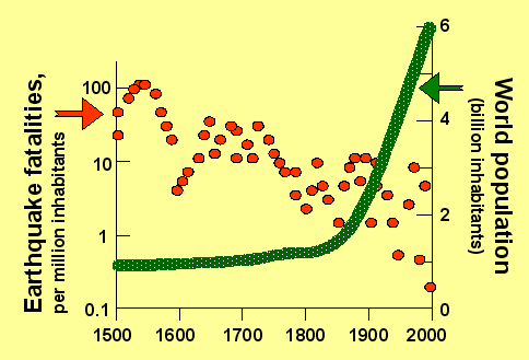
Earthquakes are likely to occur just as frequent today, for instance, as they always have through the earth�s history. But then, while the world population has been rising exponentially, earthquake fatalities have been actually declining, when normal�ized for this population growth. A better understanding of where and why these earthquakes and the resulting fatalities occur has |
|


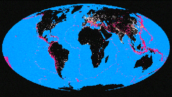
clearly helped. This is despite the fact that, as the above map shows,
most of the world
population lives in the regions that tend to be particularly earthquake-prone.
Much remains to be done as yet, however, judging from the experi�ence of the magnitude 9 �Great� Sumatra earth�quake of December 2004 and the Indian Ocean tsunami. This disaster�s 200,000-plus fatality count belies the fact that tsunami arrival times are predict�able, even though the wave ampli�tudes are not.
|
Tsunami arrival times, in hours, from the December 2004 Sumatra earthquake (star denotes the epicenter of the magni�tude 9 temblor off Bandar Aceh, Sumatra)
|
|
n The issues like global warming, environmental and/or evolutionary impacts of catastro�phic events, waste disposal, coastal habitat etc.
Earth�quakes and volcanism hardly produce calamities on the same scale as those related to climate, however, as the chart below shows. Note that almost one-half of the disaster fatalities worldwide during 1971-96 were
|
|
related to
climate,
(Source: |
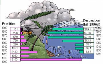
Mitigation efforts do substantially lower the fatalities from disasters like floods and hurri�canes, at exponentially rising costs though, judging from the 20th century U.S. statistics summarized below. This only worsens the lot of the socio-economi�cally less advantaged countries even more, however, as the chart below clearly shows.
|
|
The 20th century U.S. hurricane fatalities and destruction
As for the climate related problems, two emerging issues, both associated with global warming, raise particular alarm:
―
through the 20th
century, precipita�tion has appreciably declined in the 0�-30�N latitude band,
so hurting farming and raising the pros�pects of water-wars in the region where
most of the world lives; and
― if the melting of polar icecaps weakens Gulf Stream and destroys the Global Conveyor Belt of thermohaline circulation ― the two ocean currents that keep Europe warmer than usual ― then Europe may abruptly revert to an Ice Age similar to what lasted during 13th through 17th centuries.
n The potential exhaustibility of mineral and energy resources.
The availability and use of mineral and energy resources has defined our economic well being throughout history. Many of these resources tend to be exhaustible, however. In the case of metallic minerals, supply has largely kept pace with the demand for most of the 20th century, thanks to advances in extraction technology. Not surprisingly, therefore, the long-run inflation-adjusted world prices of the nonferrous metals such as aluminum, copper, tin and zinc have only fluctuated since 1920 about their 1977-79 levels. But the recent upsurge in their demand can rapidly alter this scenario.

Energy resources, particularly oil and natural gas, present a far more disconcerting scena�rio. For instance, recent USGS estimates, tabulated below, suggest that we have already used up about 18% of the world�s total oil and natural gas endow�ment of almost 6 trillion barrels of oil equivalent.
|
http://www.usgs.gov/public/press/public_affairs/press_releases/pr1183m.html |
This does not seem alarming until we realize that, in another 40 years or so, we will be well past the Hubbert peak when one-half of the resource has been used up, and will be then have to contend with poor quality and high extraction costs, even if the worldwide demand rises at a modest 10% annual rate. The graph of world crude oil prices since 1970, in the nominal (or current) as also real or inflation-adjusted U.S. dollars, shown below (http://www.bp.com/ and http://www.eia.doe.gov) is very revealing in this respect. Note the rising trend since 1997-98, raising the ominous prospects of the return of the 1970s.

1.3 Geology and the Scientific Approach:
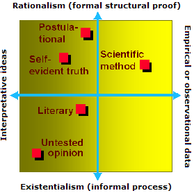
Geology is perhaps the friendliest face of science that we encounter in daily life, whether at work, or at home, or when we visit a National Park! Science is a continuous quest for the basic rules that apply equally all over the universe. Discovering these rules over such a vast single system then becomes a process of rationalizing empirical observations and securing better observations to refine the resulting structural formal�ism �
|
|
as the schematic illustration alongside explains, scientific process necessitates amenability to falsi�fi�cation as the basic premise for any model or proposal. How else can the theoretical construct as also the empirical data be examined conjunctively if we are to ascribe finality to either of them as the prelude to any enquiry? |
Unlike most other lines of scientific enquiry, considerations of space and time severely limit laboratory modeling of the earth processes, however. This is hardly an insurmountable problem. For instance, the notion that San Andreas Fault is a boundary along which North American plate has slipped by ~600 Km relative to Pacific plate in the past ~80 Ma can be easily disproved by producing incontest�able evidence that rocks younger than this age occur adjacent to one another across the fault. What we notice, instead, is that ~24 Ma old volcanics here have been offset by ~330 km.
|
|
The off-setting of ~80 Ma old Sierra Nevada granites by the San Andreas Fault. The map on the left is a reconstruction of what these granite outcrops may have been like when they were emplaced while that on the right shows how the block to the west of the Fault has moved north relative to the other block. |
|
Formidable as they sound, these numbers are hardly unverifiable. A kilometer of displacement in a million years simply implies a millimeter of average annual displacement, after all, or a centimeter of displacement over a decade. Therefore, as the above geological data correspond to rates of 7.5 mm/year for the past ~80 Ma that accelerated to ~11mm/year in the past ~25 Ma, proving these inferences merely requires observing a ~10 cm decadal displacement along this fault, as we indeed do.
1.4 Three Basic Assumptions:
The following three assumption are therefore basic to geological studies.
n Present is the key to the past, i.e., the geological processes taking shape today are the same as they have always been.
For instance, limestone is essen�tially an marine sediment, and forms in the deep ocean bottom by way of precipitation of Calcium Carbo�nate (CaCO3) or, in the case of shallow coastal seas, from the accumulation of organic debris. Thus, since Mount Annapoorna, the 8,091 m (or 26,545 ft) tall Himalayan peak, is made up of limestones with ~200 Ma (million years) old Ammonite fossils ― and ammonites was a deep sea creature ― we would conclude that an ocean existed, ~200 Ma ago, at the site where we now have Himalayas, the world�s loftiest mountains today, whose rise apparently resulted from the uplift of that deep sea floor.
|
|
The limestone peak of Mount Annapoorna, the Himalayas. |
|
|
The presence |
|
|
|
of ammo- |
||
n In an undisturbed succession of layers, the one at the bottom is the oldest (this is the principal of superposi�tion of strata).
A case in point would be the majestic Grand Canyon of Colorado River, a 1.5 km deep, 15 km wide and 450 km long canyon that exposes ~2 Ga (billion years) history of sedimentation, mountain building and erosion. Note that the Paleozoic sediments exposed in the following view of the Canyon are largely horizontal. Now look at their ages, in the geological
|
|
|
|
|
section of part of Colorado Plateau from Grand Canyon on the left to Zion seen as buttes towards the right, shown in the bottom map, and notice how the ~250 Ma old Kaibab Limestones overlie the ~550 Ma old Bright Angel Shales.
n The principle of cross-cutting relationships, i.e., an intrusive rock is bound to be younger than the rock formations it intrudes.
The above geological section of the Grand Canyon also has an excellent example of this common sense principle and its use. Notice how the ~1.25 Ga old Zoraster Granite has cut across the older, ~2 Ga old, Vishnu Schist formation but not into the younger Bright Angel Shales.
Another example of this is the famous Ship Rock in New Mexico. Shown below, this is a volcanic neck that now rises 420 meters above the desert floor in the 30-35 Ma old Navajo Volcanic field.
|
Source: http://pubs.usgs.gov/gip/volc/structures.html |
2. The Earth as a Planet
2.1 Earth�s Neighborhood
|
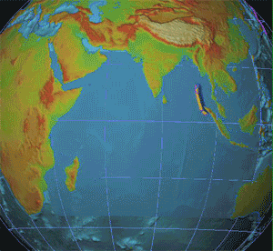
Earth, our home and the '3rd Rock from the Sun', is also called the 'Lonely Planet' because, to our knowledge as yet, earth is the only planet with the evidence of life. It is called the 'Blue Planet' because of the abundance of water on Earth's surface.
|
These two websites provide excellent information on the Solar System. |
|
|
|
||
|
|
|
|
|
Compositionally, only few of the elements from the Periodic Table actually dominate the Solar System. Of these, three groups of elements form the major consti�tuents of Solar System:
� the gaseous elements H and He (e.g., Sun, Jupiter and Saturn), |
|
� the ice-forming elements C, N, O that occur as solid NH3 (ammonia) and CH4 (methane) and H2O (ice) (e.g., Uranus, Neptune), and
� the rock-forming elements Mg, Fe and Si (e.g., the inner or terrestrial trial planets � Mercury, Venus, Earth, Mars) and the asteroids and Moon

2.2 What makes Earth the �Water Planet�?
Clearly, were the supply of hydrogen and oxygen the principle reason why Earth has such an abundance of water (H2O) then the other members of the Solar System too should have had abundant supplies of water. That is not the case, however.
Two reasons explain why water, which should occur all over the Solar System wher�ever the tem�pe�ra�tures are between 0�C and100�C, is abundant on Earth but a rarity elsewhere: (a) hydro�logical cycle and (b) plate tectonics.
2.3 The Hydrological Cycle
Of these, hydrological cycle is the conti�nuous recycling of water between oceans, atmos�phere and land. As the run-off from land would eventually fill up the ocean basins and level the land, hydro�logical cycle carries the seeds of its own destruction because the resulting smoothen�ing of the surface eventually translates into the drying up of the Earth.

Note that oceans lose more water by evaporation than is returned by precipitation, while the opposite occurs on land. The run-off from land thus completes this hydrological cycle.
One can thus think of the hydrological cycle as comprising two sub-cycles. In the case of land, P (precipitation) = E (evaporation) + R (run-off) where-as, in the case of the oceans, E (evaporation) = P (precipitation) + R (run-off).
Three questions thus arise:
� What if atmosphere retained some water, instead of returning all the evaporation back as precipitation? Perhaps we may then end-up with a foggy Earth, as was perhaps the case in the Devonian times, known as the �Age of the Fish�, when the overall climate was appreciably arid.
n Plate tectonics, on the other hand, involves the crea�tion of new surface area, as ocean basins that form from incessant volcanic injections at the spreading submarine ridges, and an equal surface area is lost in the folded mountain belts and deep sea trenches. This explains why the ocean floor is made up of basalt, a vol�canic rock. Obviously, the water on Earth would have long disap�peared had plate tectonics not existed to continually create the ocean basins that hydrological cycle would then fill up. Earth remains the water planet because (a) temperatures over most of the Earth�s surface are be�tween 0�C and 100�C, (b) temperature gradient in the troposphere is steep enough to allow the precipita�tion of atmospheric moisture, (c) the hydrological cycle has been perennially present, and (d) plate tectonism has occurred throughout, ever since the oceans evolved 3.7-4 billion years (Ga) ago.
|
|
![]()
[1] The chapter numbers here refer to those in the textbook: PHYSICAL GEOLOGY: EARTH REVEALED by David McGeary and Charles Plummer (WCB/McGraw-Hill, 2002). You can also explore the companion website of the book�s other version (you will need to match the chapter titles here, though, because the sequencing of chapters in the version presented online differs from your video-adapted version) at the URL: http://www.mhhe.com/earthsci/geology/plummer/student.mhtml
This site was last updated 05/05/15