Earth's Interior

Updated on
05/05/2015
|
Earth's Interior |
|
||||
| Home My Book Physical Geology Environmental Geology Oceanography |
|
|
|||
|
Updated on |
|||||
|
|
 |
A discussion of the earth�s interior is the basic prerequisite for understanding Physical Geology partly because of the role of planetary dynamics in creating and sustaining the planetary processes and partly because the tools that inform us of the planetary interior are also the ones we need in our understanding of the surface effects. |
| Access this USGS publication �Interior of the Earth� at http://pubs.usgs.gov/gip/interior |
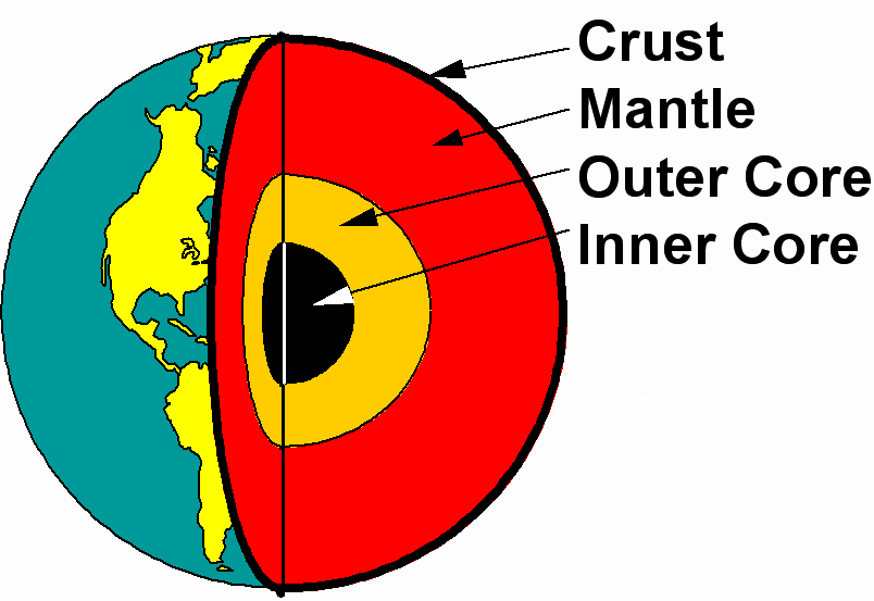
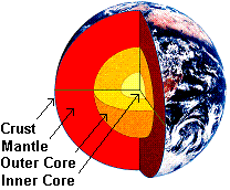
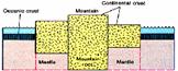
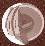
� Crust is the earth's thin (0-70 Km) outer skin, averaging ~30 Km beneath the continents and ~15 Km beneath the oceans.
� Mantle is the earth's ~2,900 Km thick and rocky outer shell that underlies the crust.
� Core is the earth's ~3,500 Km thick metallic interior, comprising the (a) solid inner core (1,250 Km radius), and (b) liquid outer core (2,250 Km thick).
(Inner core and crust have similar volumes of ~8.2�109 Km3)n Earth is a multi-layered body
� Crust is the earth's thin (0-70 Km) outer skin, averaging ~30 Km beneath the continents and ~15 Km beneath the oceans.
� Mantle is the earth's ~2,900 Km thick and rocky outer shell that underlies the crust.
� Core is the earth's ~3,500 Km thick metallic interior, comprising the (a) solid inner core (1,250 Km radius), and (b) liquid outer core (2,250 Km thick).
(Inner core and crust have similar volumes of ~8.2�109 Km3)
|
|
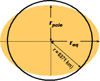
Earth's equatorial radius (req) is ~21 km greater than the polar radius (rpole).
|
||||||
|
||||||||
|
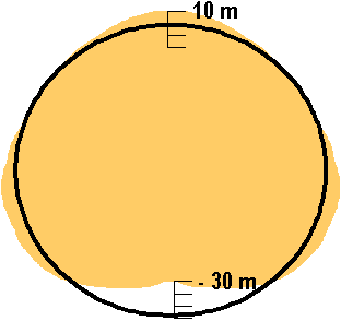
Based on satellite mapping, the earth is now known to be truly pear-shaped, in that, added to facts of earth�s equatorial bulge and polar flattening, the south pole is ~40 m closer to the earth�s center than the north pole. |
||||||||
|
|
|||||||
|
|||||||
Curiously, for whatever its significance, the inner core and the crust have similar volumes of ~8.2�10
|
|||||||
|
|
||
|
|
|
|||||||
|
|
||||||||
|
|
||||||||||||||||||||||||||||||||||||||||||||||||||||||||||||||||||||||||
|
|
|||||||||||||||||||||||||||||||||||||||||||||||||||||||||||||||||||||||
|
|
||||||||||||||||||||||||||||||||||||||||||||||||||||||||||||||||||||||||
|
||||||||||||||||||||||||||||||||||||||||||||||||||||||||||||||||||||||||
|
||||||||||||||||||||||||||||||||||||||||||||||||||||||||||||||||||||||||
|
||||||||||||||||||||||||||||||||||||||||||||||||||||||||||||||||||||||||
|
|
|||||||||||||||||||||||||||||||||||||||||||||||||||||||||||||||||||||||
|
|
||||||||||||||||||||||||||||||||||||||||||||||||||||||||||||||||||||||||
|
||||||||||||||||||||||||||||||||||||||||||||||||||||||||||||||||||||||||
|
n Earth has a multi-layered structure: |
||||||||||||||||||||||||||||||||||||||||||||||||||||||||||||||||||||||||
|
|
Earth�s Interior |
|||||||||||
|
|
||||||||||||
|
|
� � �

|
|
||||||||||
|

|
� c � � n The Gravity Picture: |
|
|
|||||||||
|
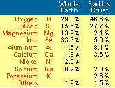
� Because of earth�s equatorial bulge and polar flattening, gravitational acceleration on the surface increases from equator to the poles. � The whole earth density (~5.5 g/cm3) is about |
|
|
||||||||||
|
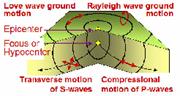
twice the average crustal density (~2.7 g/ cm3): Clearly, density increases with depth. � The continental crust is lighter and thicker than the oceanic crust, as �mountains have their own roots� (i.e., isostasy). n The Seismic Evidence � Seismic waves are of two types: the surface waves (Love and Rayleigh) and |

|

|
|
|||||||||
|
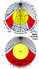
the
body waves (the P and S waves).
Of
these, P-wave � Earthquake focal depths are usually <250 Km. � The �shadow zone�: No direct P-waves from an earthquake. |
|
|
||||||||||
|
arrive between 103� and 142� from the epicenter, whereas
n

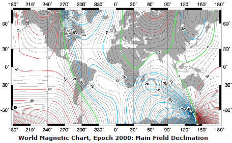
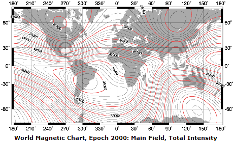
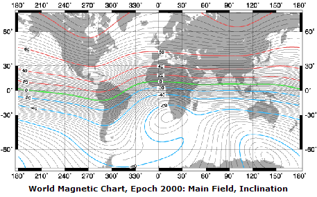
The Geomagnetic Field
|
|
|
||||||||||
|
|
|
|||||||||||
|
To learn about the geomagnetic field, visit the National Geophysical Data Center at http://www.ngdc.noaa.gov/seg/potfld/geomag.shtml |
|
|||||||||||
|
n Why is the Outer Core fluid? |
Because temperatures
there exceed the melting
|
|
||||||||||
|
Help available 'Online' |
|
Help available at this site |
||||||||||||||||||||||||||||||||||||||||||||||||||||
|
|
|
You may need to download the Adobe Acrobat Reader to view this PDF file |
|||||||||||||||||||||||||||||||||||||||||||||||||||
|
Click on this image to access the USGS online publication "Interior of the Earth" |
 |
|||||||||||||||||||||||||||||||||||||||||||||||||||||
|
||||||||||||||||||||||||||||||||||||||||||||||||||||||
|
||||||||||||||||||||||||||||||||||||||||||||||||||||||
|
Access these USGS sites to find out |
|
|
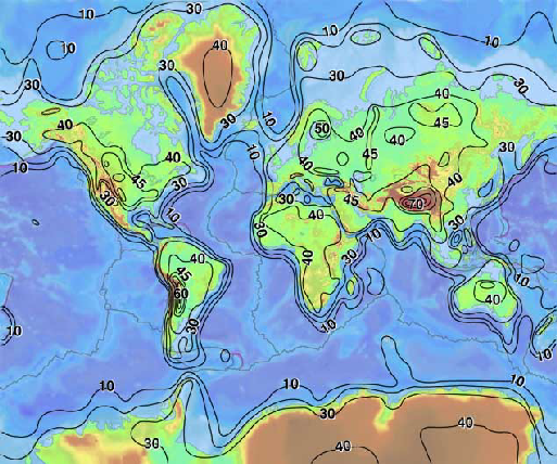
This USGS (http://quake.usgs.gov/research/structure/CrustalStructure/) contour map of the thickness of the Earth's crust shows that, to a first approximation, the continents and their margins are outlined by the 30 km contour. That portion of the continental interior enclosed by the 40 km contour, and regions with crustal thickness of 45 to 50 km are found on all well surveyed continents (i.e., North and South America, Australia, and Eurasia). Continental crust with a thickness in excess of 50 km is exceedingly rare and accounts for less than 10% of the continental crust. The contour interval is 10 km; with the 45 km contour included for greater detail on the continents. |
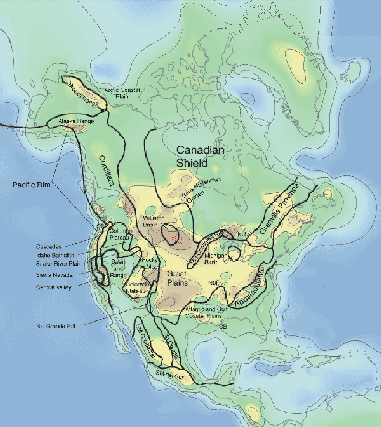
The figure on the right is the USGS crustal thickness map of North America, derived from a comprehensive compilation of seismic refraction and reflection data, earthquake studies, and surface wave analyses. Notice the extension of the thin crust of the Basin and Range Province into Western Canada. The contour interval is 10 km (solid line) (dashed line shows the 45 km contour. The average thickness of the North American continental crust, including margins, is 36.5 km ranges from 14 km to 60 km. |
 |
 |
|
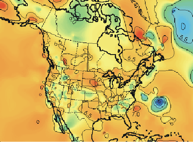
This USGS map of North America alongside shows the average p-wave velocity of consolidated or crystalline crust (Pcc) without sediments. Notice
Source:
http://quake.usgs.gov/research/structure/ |
|
|
The Geomagnetic Field Earth's magnetic field generally behaves as one produced by a bar magnetic aligned to the spin axis, as can be seen from these world magnetic charts for epoch 2000 produced by the USGS, jointly with the British Geological Survey. Its precise mechanism, and the reason why it occasionally flips over and reverses its polarity, remain far from clear as yet, however. Try the following URLs to learn more about this subject: http://www.earth.rochester.edu/ees201/Rudin/rudin.html http://www.psc.edu/science/Glatzmaier/glatzmaier.html#References |
 |
 |
 |
Note: Rotating globe at the top left corner of this page is from http://adinet.net/Globe_HTML/frames/scientific/f2p3a7_78kb2.htm
This site was last updated 05/05/15